
Planning Resources:
Photographs, Maps, and Memorabilia
- 1948 Nations Geographic Map of Foggy Bottom
- Historic Base Map of 27th and I Street, NW
- 1965 Baist Map of Foggy Bottom
- Foggy Bottom & Whitehurst Freeway Overview
- Historical photographs of Foggy Bottom
- Street level photographs
- Watergate East The First 25 Years
Ground Truth
- SITE-6 Old GWU Dorm and DOT Properties
- SITE-5 Gas Station Property
- SITE-4 Gas Station & Road Right of Way
- SITE-2 City/Private Property
- SITE-3 Department of Transporation (DOT)Â Property
- SITE-1 Private Property
Development Proposals 1992 – 2004
- Watergate North Proposal — March 1998
- Watergate North Zoning Analysis_4-16-1999_1
- Watergate North Plan View
- DC Department of Public Works Letters to Dale Barnhard 6-25-1998
- Prospective Development of 2690 Eye St — February 2002
District Comprehensive Plan
- Current Comprehensive Plan
- Proposed Amendments 2017
- 2.5 Foggy Bottom West End Proposed Introduction Amendments
- 2.5 Foggy Bottom West End Proposed Policy Amendment
Community-Related Presentations and Reports
- National Capital Planning Commission Kennedy Center Accessibility Study
- EEK Reclaim the City Fabric Presentation
- EEK Citywide Highway Repair Study
- Whitehurst Freeway Existing Conditions Report
DC Office of Zoning
- DCOZ_report_201544-Square-1
- DCOZ_report_201544-Satellite
- DCOZ_report_201544-Satellite-try-2
- DC-Base-Map-27th-and-I-Street
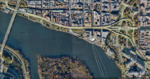
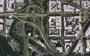
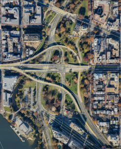
Aerial Photographs

This list and the links are a work in progress. Suggestions for additional items to add to this collection are most welcome.  Please send a copy to the attention of barnhard@barnhard.com.